 |
||||||||||||||||||||||||||
 |
 |
 |
||||||||||||||||||||||||
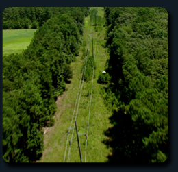
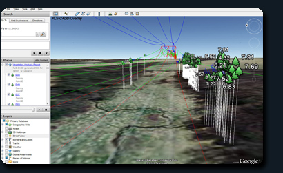
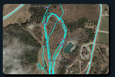
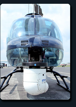
| The source for Geo-Referenced HD Video and Multimedia for maximum situational awareness. | Aerial Surveys and Aerial Mapping for all industries and uses including:Urban Planning: Land use planning incorporating HD aerial video with GIS data for scene and object level understanding. Videos captured using low flying aerial platforms consists of well defined and visually accurate representation of non-ground-plane structures, revealing it contains rich information about the 3D nature of the scene as well as the relationship of moving objects to each other within the scene. Oil, Gas and Electric Industry: NERC Vegetation management survey's. Imaging services for planning, designing sites, infrastructure improvements and pipeline & transmission network inspections for the Oil, Gas, and Electric industries. Real Estate Industry: Real estate customers can directly benefit from the advanced visualization capabilities of our HD video technology which can then be integrated with other complementary technologies such as still photos and panorama imaging to produce complete data. Travel and Tourism: Travel services, property owners and local/city governments can benefit when planning for clients including hotels, restaurants, features and points of interest. Wildlife Surveys with Geo-Referenced Multimedia Mapping Services: Data Collection: the multimedia is collected via helicopter and fixed-wing airplane utilizing stabilized IR and visual digital cameras. Geo-referenced Multimedia: Video and still images have embedded gps data, allowing exact location verification. Mapping: Visualize the magnitude of resources available in simply Google Earth, allowing you to view still images or video footage associated with each location independently. The video and still images can be exported in many formats to meet your specification. For permanent reference, visualization and data collection archiving. Data can be exported to ArcView shapefile for import into GIS of your choice, also many graphics formats. Programs also available for educational purposes. Call 1-888-373-4539 for more information
|
|||||||||||||||||||||||||
| Island Century Media (ICM) is an aerial camera services operator. Providing Geo-Referenced Multimedia Mapping Services. We specialize in providing Live streamed video from virtually any location in the Continental United States. We are your first choice when you need situational awareness. | ||||||||||||||||||||||||||
 |
||||||||||||||||||||||||||
Copyright 2010 :: all rights reserved icm4hd.com :: 888.373.4539 |
||||||||||||||||||||||||||